Drainage System of India
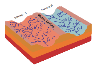
The term drainage describes the river system of an area. The area drained by a single river system is called a drainage basin. A closer observation on a map will indicate that any elevated area, such as a mountain or upland, separates two drainage basins. Such an upland is known as a water divide.
The drainage systems of India are mainly controlled by the broad relief features of the subcontinent. Accordingly, the Indian rivers are divided into two major groups:
- the Himalayan rivers; and
- the Peninsular rivers.
Apart from originating from the two major physiographic regions of India, the Himalayan and the Peninsular Rivers are different from each other in many ways. Most of the Himalayan Rivers are perennial. It means that they have water throughout the year. These rivers receive water from rain as well as from melted snow from the lofty mountains. The two major Himalayan Rivers, the Indus and the Brahmaputra originate from the north of the mountain ranges. They have cut through the mountains making gorges. The Himalayan Rivers have long courses from their source to the sea. They perform intensive erosional activity in their upper courses and carry huge loads of silt and sand. In the middle and the lower courses, these rivers form meanders, oxbow lakes, and many other depositional features in their floodplains. They also have well-developed deltas. A large number of the Peninsular Rivers are seasonal, as their flow is dependent on rainfall. During the dry season, even the large rivers have reduced flow of water in their channels. The Peninsular Rivers have shorter and shallower courses as compared to their Himalayan counterparts. However, some of them originate in the central highlands and flow towards the west. Most of the rivers of peninsular India originate in the Western Ghats and flow towards the Bay of Bengal.
1. HIMALAYAN DRAINAGE SYSTEM
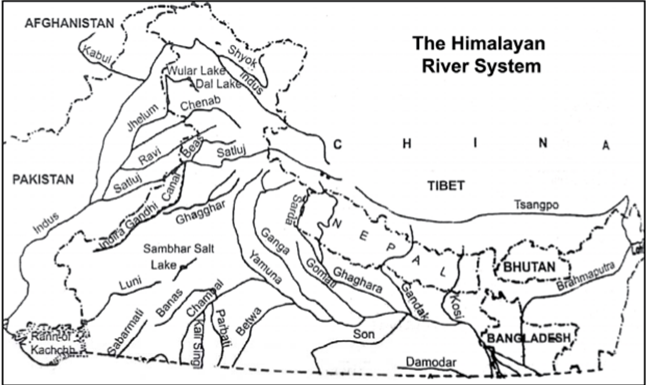
Indus River System
- Indus River is great trans-Himalayan river of South Asia. It is one of the longest rivers in the world, with a length of some 1,800 miles (2,900 km). Its total drainage area is about 450,000 square miles (1,165,000 square km), of which 175,000 square miles (453,000 square km) lie in the Himalayan ranges and foothills and the rest in the semiarid plains of Pakistan.
- The Indus originates in the Kailash range in Tibet near Lake Manasarovar. It follows a north-westerly course through Tibet. It enters Indian Territory in Jammu and Kashmir. It forms a picturesque gorge in this part. Several tributaries - the Zaskar, the Shyok, the Nubra and the Hunza join it in the Kashmir region. It FLows through the regions of Ladakh, Baltistan and Gilgit and runs between the Ladakh Range and the Zaskar Range. It crosses the Himalayas through a 5181 m deep gorge near Attock, lying north of the Nanga Parbat and later takes a bend to the south west direction before entering Pakistan. It has a large number of tributaries in both India and Pakistan and has a total length of about 2880 km from the source to the point near Karachi where it falls into the Arabian Sea. The main tributaries of the Indus in India are Jhelum, Chenab, Ravi, Beas and Sutlej.
- The principal rivers of the Indus River system are snow-fed. Their flow varies greatly at different times of the year: the discharge is at a minimum during the winter months (December to February); there is a rise of water in spring and early summer (March to June); and foods occur in the rainy season (July to September). Occasionally there are devastating flash foods. The Indus and its tributaries receive all their waters in the hilly upper parts of their catchments. Therefore, their flow is at a maximum where they emerge out of the foothills, and little surface flow is added in the plains, where evaporation and seepage considerably reduce the flow volume. On the other hand, some water is added by seepage in the period after the monsoon months. In the main stream of the Indus, the water level is at its lowest from mid December to mid-February. After this the river starts rising, slowly at First and then more rapidly at the end of March. The high-water level usually occurs between mid-July and mid-August. The river then falls rapidly until the beginning of October, when the water level subsides more gradually.
The Ganga River System
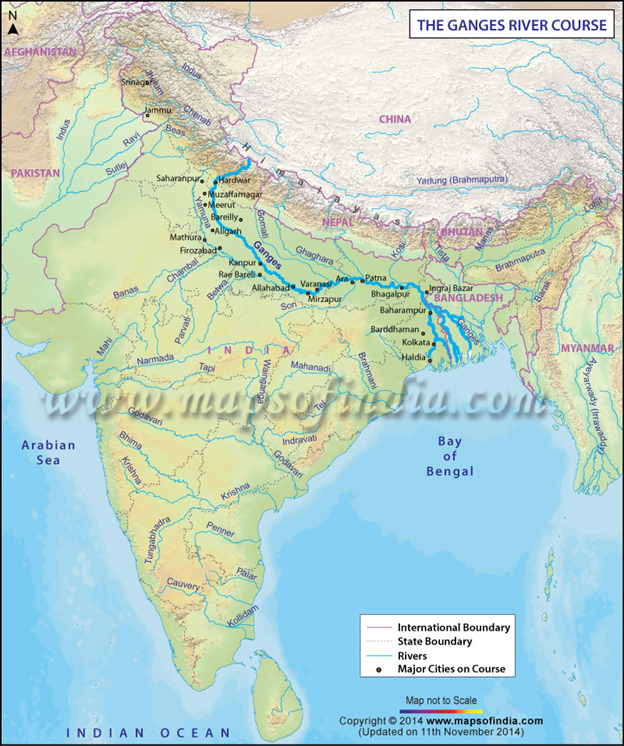
- The Ganga river system consists of the River Ganga and a large number of its tributaries. This system drains a very large area comprising the middle part of the Himalayas in the north, the northern part of the Indian Plateau in the south and the Ganga Plain in-between. The total area of the Ganga basin in India is 861,404 sq. km which accounts for 26.3 per cent of the geographical area of the country. This basin is shared by ten states. These states are Uttaranchal and Uttar Pradesh (34.2%), Madhya Pradesh and Chhattisgarh (23.1%), Bihar and Jharkhand (16.7%), Rajasthan (13.0%), West Bengal (8.3%), Haryana (4.0%) and Himachal Pradesh (0.5%). The Union Territory of Delhi accounts for 0.2% of the total area of the Ganga Basin.
- The Ganga originates as Bhagirathi from the Gangotri glacier in Uttar Kashi District of Uttaranchal at an elevation of 7,010 m. Alakhnanda joins it at Devaprayag. But before Devaprayag, the Pindar, the Mandakini, the Dhauliganga and the Bishenganga rivers pour into the Alaknanda and the Bheling flows into the Bhagirathi. The total length of the Ganga River from its source to its mouth (measured along the Hugli) is 2525 km, of which 310 km in Uttaranchal, 1140 km in Uttar Pradesh, 445 km in Bihar and 520 km in West Bengal. The remaining 110 km stretch of the Ganga forms the boundary between Uttar Pradesh and Bihar.
- Before entering the Bay of Bengal, the Ganga, along with Brahmaputra, forms the largest delta of the world between two arms: the Bhagirathi Hugli and the Padma/Meghna covering an area of 58,752 sq km. The delta front of the Ganga is a highly indented area of about 400 km length extending from the mouth of the Hugli to the mouth of the Meghna. The delta is made of a web of distributaries and islands and is covered by dense forests called the Sunderbans. A major part of the delta is a low- lying swamp which is flooded by marine water during high tide.
Brahmaputra River System
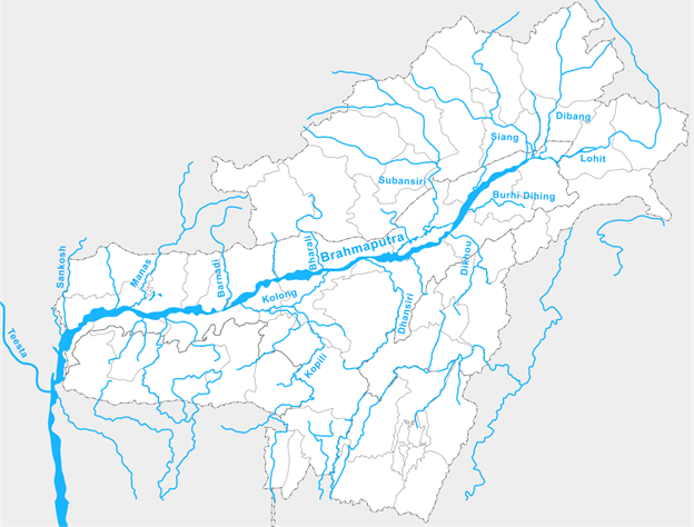
- The river Brahmaputra covers a catchment area of about 5,80,000 Sq.km. right from its origin in Himalayan Lake Manasarover at an elevation of about 5,150 m in Tibet to the outfall in the Bay of Bengal. It flows eastward in Tibet and south, south-west in India and traverses a distance of about 2900 km out of which 1,700 km is in Tibet, 900 km is in India and 300 km is in Bangladesh. In the upper reaches, the river is fed by the glaciers and in the lower reaches, it is joined by a number of tributaries which originates at different elevation in the hills encircling the catchment, forming watershed. Among the tributaries Subansiri, Manas, Jiabharali, Pagladiya, Puthimari and Sankosh, etc are snow fed.
- The Tibetan name of river is “TSANGPO” and Chinese name is “YALUZANGBU”. The watershed area is mostly on the northern side of the river in this region. After traversing a distance of about 1700 km eastwardly, the river changes its course from east to south and then enters the Arunachal Pradesh in Indian Territory. Its name also changes from “TSANGPO” to Siang and Dehang in Arunachal Pradesh. The river then flows almost in Southern direction for another distance of about 200 km upto Passighat. Before touching plains it is joined by two major Himalayan tributaries viz. Lohit and Debang. The combined flow of these rivers is known as the Brahmaputra and passes through the plains of Assam and Bangladesh before falling into the Bay of Bengal. From Passighat to Dhubri where it travels in plains of Assam is well known as Brahmaputra valley.
- The important tributaries of River Brahmaputra are:
- Left bank tributaries: Dhansiri, Kapili, Barak.
- Right bank tributaries: Subansiri, Jia Bhoraeli, Manas, Sankosh, Tista & Raidak
- Dhansiri: Rises from Naga Hills.
- Sankosh: It’s the main river of Bhutan, meets Brahmaputra at Dhubri, Assam.
- Manas: Rises from Tibet and joins Brahmaputra on its right bank.
- Subansiri: It is flows in between the Mikir hills & Abor hills and later joins Brahmaputra on its right bank.
- Tista: Rises from Kanchan-junga, fed by the tributaries like Rangit & Rangpo, it joins the Brahmaputra river in Bangladesh.
- Barak: Rises in Nagaland. It enters Bangladesh as River Surma which falls into River Padma at Chandpur.
2. DRAINAGE SYSTEM OF PENINSULAR INDIA
Origin of Peninsular Drainage
- Subsidence of western flank of peninsula during early tertiary period. It his disturbed the symmetry of peninsular block’s river watershed.
- Upheaval of the Himalayas when the northern flank of peninsular block was subjected to subsidence and consequent trough faulting. The Narmada and Tapi flow in trough faults and fill the original cracks with detritus materials. Hence there is lack of alluvial and deltaic deposits in these rivers.
- Slight tilting of peninsular block from North-West to South-East has caused entire drainage system to flow towards Bay of Bengal.
- Types of Peninsular River System (On the basis of direction of flow)
- West flowing rivers
- East flowing Rivers
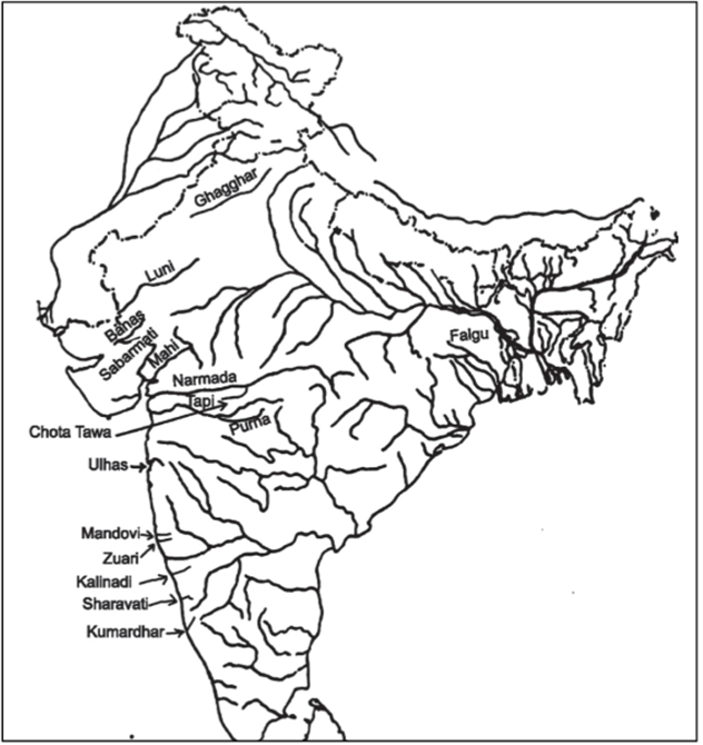
West flowing Rivers
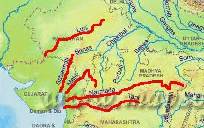
Narmada
- Origin – Amarkantak plateau (1,057m) (Shahdol district, Madhya Pradesh)
- Total Length– 1,310 km (largest west flowing river) Only 112 km navigable from mouth.
- Flows 1,078 km in Madhya Pradesh Forms 32 km long boundary between M.P and Maharashtra.
- Forms 40 km long boundary between Maharashtra & Gujarat Flows 160 km in Gujarat
- Makes an estuary before entering into Gulf of Khambhat.
- There are several islands in estuary formed by Narmada. Aliabet is an important estuary island.
- States – M.P., Maharashtra, Gujarat
- Landmarks – Dhuan Dhar falls also called cloud of mist (30m) located in Jabalpur district, Madhya Pradesh. This fall is located in a Gorge of marble.
- Other falls- Mandhar falls (12m)Dardi fall (12m) Sahasradhara falls (8m)
The Tapi (or Tapti)
- Origin – Betul plateau (M.P) in Satpura Range
- Total length – 730 km (32 km from sea)
- State – M.P, Maharastra & Gujrat
- Meets- Arabian Sea at Gulf of Khambhat
The Sabarmati
- Sabarmati River is formed by confluence of Sabar and Hathmati streams
- Origin – Mewar hills (Aravali range) (Rajasthan)
- Length – 320 km
- Mouth – Gulf of Khambhat
- States – Rajasthan & Gujarat
- Tributaries – The Sedhi, The Harnav, the Vartak, the Wakul, The Meshwa
The Mahi
- Origin – Vindhyas (500 m)
- Meeting point – Gulf of Khambat
- States – Madhya Pradesh, Maharastra & Gujrat
- Length – 533 km
- Tributaries – Som, Anas and Panam
Luni
- Also known as ‘Sagarmati’
- It flows through ‘Thar Desert’
- It has an Inland Drainage as it disappears into Marshy land of Rann of Kutch
- Origin – Aravalli (west of Ajmer, Rajasthan)
- Length – 482 km
- Meeting point – Lost into Marshy land of Rann of Kutch (Inland drainage)
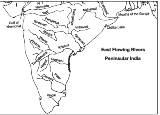
East Flowing Rivers
Damodar
- Origin – Chhotanagpur plateau
- Length – 541 km
- Its joins the Bhagirathi – Hooghly in West Bengal
- Also known as ‘Sorrow of Bengal’
Suvarnrekha
- Origin – Ranchi plateau
- Length – 474 km
- Tributaries –Baitarni & Brahmani
- It flows in States of Jharkhand and Orissa
Mahanadi
- Origin – Dandakaranya (near Sihawa, Raipur, Chhattisgarh)
- Length – 857 km States –
- It flows in Chhattisgarh and Odisha.
- It forms delta of about 9,500 km sq.
Rushikulya River
- Origin – Nayagarh hills (Odhisha)
- Length – 165 km
- States – Its flows in Odisha
- It flows near Chilka lake (largest brackish water lake of Asia)
- Mouth of Rushikulya River is known for mass hatching of olive ridley turtles. This is smallest and most abundant of all sea turtles found in the world.
- Olive Ridley turtles are only found in tropical waters of Pacific, Altantic and Indian Ocean.
Godavari River
- Origin – Trimbak plateau (Nashik, Maharashtra
- Length – 1,465 km States – Maharashtra, Andhra Pradesh, Telangana
- It is second largest river of India and largest river system of Peninsular India
- It is also called Gautami or Virdhha Ganga
Krishna River
- Origin – Western Ghats just north of Mahabaleshwar (Maharashtra)
- Length – 1400 km
- State – Maharashtra, Telangana, Karanatka, Andhra Pradesh
Penneru
- Origin – Nandidurg Peak (Karnatka)
- Length – 597 km
- State – Karnatka and Andhra Pradesh
- Tributaries-Kundur, Charavati, Papagni, Punchu
Kaveri
- Origin – Taal Kaveri (Bramhagiri Range, Western Ghat, near Bengaluru, Karntaka)
- Length – 800 km
- States – Karnatka, Tamil Nadu
- It receives rainfall from both South-West monsoon as well as retreating north-east monsoon due to which it causes food in its lower course during winter.
- One of the most well utilized rivers having 90-95% capacity utilized.
- Forms delta before merging into Bay of Bengal.
- Sivasamudram waterfalls (101 m high) are situated on it.
Vaigai River
- Origin – Varushand hills (near Annamalai hills & Palni hills)
- Length – 258 km
- State – Tamil Nadu
- It is a dry channel which reappears and disappears frequently.
- Madurai is located on Vaigai river
No comments:
Post a Comment